2008
TG4620 : West Somerton drainage mill
taken 15 years ago, near to West Somerton, Norfolk, England
This is 1 of 10 images, with title West Somerton drainage mill in this square
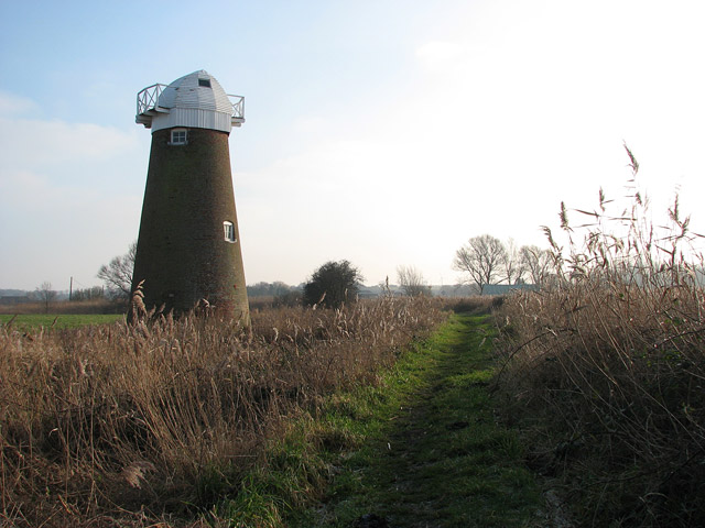
West Somerton drainage mill
Beside West Somerton Boat Dyke. The public footpath from the staithe to Martham Broad leads past here. This view was taken in southerly direction.
During the 1800s, 240 drainage mills could be found in the Broads, of which 74 remain today (most are disused and derelict, a very few were converted into living accommodation). In the 13th century most of the marsh pastures in the Broads could only be grazed during the summer months, when the area was not flooded. It was during this time that sea levels were rising and flooding became more frequent. As a consequence, dykes were dug and embankments built in order to protect the grazing marshes. When this was no longer sufficient, wind-powered drainage mills were built, which pumped water from the marshes into dykes and from there into the rivers. Grazing in the marshes became more extensive from the mid-18th century onwards - the drained marshes contain lots of nutrients and the grazing is very lush. By the 19th century many of the wind-powered mills were supplemented by steam-powered pumps and during the first half of the 20th century diesel-powered pumps started to replace wind-powered drainage. Diesel pumps are much more efficient than wind drainage pumps and as it got drier, the surrounding peaty soil shrank, resulting in areas that are lower than the water level in the river and lower even than sea level. Today the marshes are drained by pumps which are electricity-powered.
During the 1800s, 240 drainage mills could be found in the Broads, of which 74 remain today (most are disused and derelict, a very few were converted into living accommodation). In the 13th century most of the marsh pastures in the Broads could only be grazed during the summer months, when the area was not flooded. It was during this time that sea levels were rising and flooding became more frequent. As a consequence, dykes were dug and embankments built in order to protect the grazing marshes. When this was no longer sufficient, wind-powered drainage mills were built, which pumped water from the marshes into dykes and from there into the rivers. Grazing in the marshes became more extensive from the mid-18th century onwards - the drained marshes contain lots of nutrients and the grazing is very lush. By the 19th century many of the wind-powered mills were supplemented by steam-powered pumps and during the first half of the 20th century diesel-powered pumps started to replace wind-powered drainage. Diesel pumps are much more efficient than wind drainage pumps and as it got drier, the surrounding peaty soil shrank, resulting in areas that are lower than the water level in the river and lower even than sea level. Today the marshes are drained by pumps which are electricity-powered.
 Map © Crown Copyright")
TIP: Click the map for more Large scale mapping
- Grid Square
- TG4620, 90 images (more nearby 🔍)
- Photographer
- Evelyn Simak (more nearby)
- Date Taken
- Tuesday, 30 December, 2008 (more nearby)
- Submitted
- Wednesday, 31 December, 2008
- Subject Location
-
OSGB36:
 TG 464 202 [100m precision]
WGS84: 52:43.4291N 1:38.8461E - Camera Location
-
OSGB36: TG 463 203
- View Direction
- Southeast (about 135 degrees)