SK5839 : The Governor - Green's Mill
taken 13 years ago, near to Nottingham, England
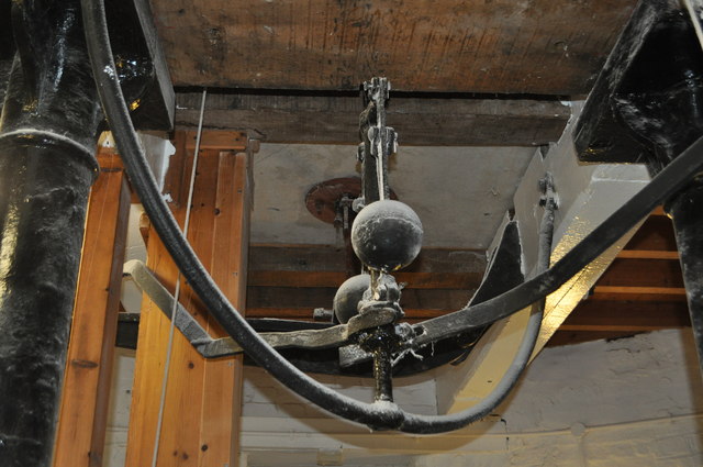
The governor is powered by the main shaft, showing the speed. The centrifugal force of the balls lifts and lowers the 'steel yard'. This in turn moves the iron tenter beam and thus minutely altering the distance between the runner stone and bottom stone. The distance effects the flour coarseness and quality.
The Mill was built shortly after 1807 by the father of 19th-century self taught mathematical physicist George Green, whose name was also George Green. It is located on the site of a previous post mill and there were at least two other mills on Windmill Lane in Sneinton. There are two stones, a pair of common sails and a pair of spring sails. In 1829 the elder Green died and his son inherited the mill and operated it until his death in 1841.
The mill was still in use until the 1860s, after which it was abandoned and gradually fell into disrepair. In 1923 a copper cap was fitted at the top to make the building watertight and this survived until a fire destroyed it in 1947.
The mill was derelict until it was acquired by Nottingham City Council in 1979. Funds were raised and it was renovated by Thompson's, millwrights of Alford, Lincolnshire in 1984 - 86. It was reopened on 2 December 1986 and is now part of a science centre which is open to the public.
 Map © Crown Copyright")
- Grid Square
- SK5839, 418 images (more nearby 🔍)
- Photographer
- Ashley Dace (more nearby)
- Date Taken
- Sunday, 14 November, 2010 (more nearby)
- Submitted
- Sunday, 14 November, 2010
- Subject Location
-
OSGB36:
 SK 585 398 [100m precision]
WGS84: 52:57.1488N 1:7.7807W - Camera Location
-
OSGB36: SK 585 398
- View Direction
- East-northeast (about 67 degrees)