2011
TG4210 : Stokesby towermill
taken 13 years ago, near to Stokesby, Norfolk, England
This is 1 of 5 images, with title Stokesby towermill in this square
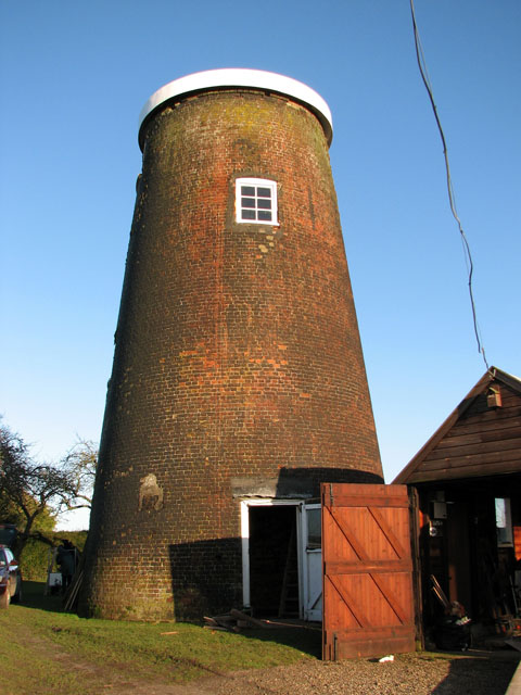
Stokesby towermill
Stokesby cum Herringby towermill originally was a 5 storeys high, tarred red brick mill. It was built in 1826 and used as a corn mill. When the last miller, Edward Elijah Trett snr., died in 1916, the mill was put up for auction and presumably never worked again. It fell into dereliction with the cap having gone by the late 1970s but the mill was weatherproof and still contained some machinery > Link. The present owner continues to restore the mill, the old wood was recently treated to protect it from woodworm and new floors are in the process of being installed. This picture was taken by kind permission of the owner.
 Map © Crown Copyright")
TIP: Click the map for more Large scale mapping
- Grid Square
- TG4210, 49 images (more nearby 🔍)
- Photographer
- Evelyn Simak (more nearby)
- Date Taken
- Tuesday, 18 January, 2011 (more nearby)
- Submitted
- Wednesday, 19 January, 2011
- Subject Location
-
OSGB36:
 TG 4296 1074 [10m precision]
WGS84: 52:38.3976N 1:35.3751E - Camera Location
-
OSGB36: TG 4294 1071
- View Direction
- North-northeast (about 22 degrees)