2009
TG3901 : Limpenhoe drainage mill
taken 15 years ago, near to Hardley Street, Norfolk, England
This is 1 of 7 images, with title Limpenhoe drainage mill in this square
Limpenhoe drainage mill
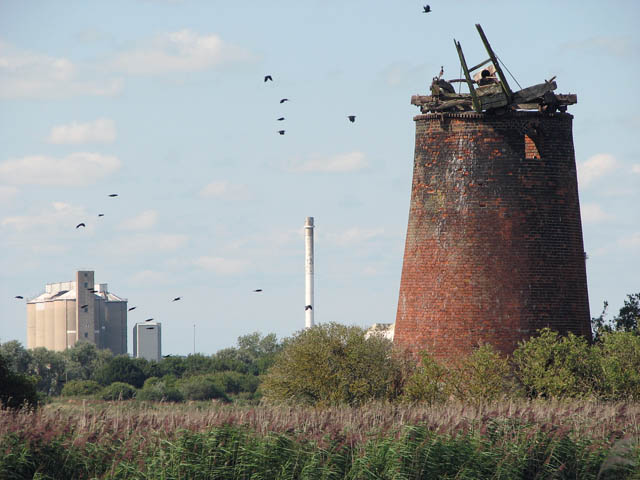
The 4-storey high Limpenhoe drainage mill > Link was built in 1831 by millwright William Thorold and it is the last surviving windmill built by him. The windpump is situated on the north bank of the River Yare which here forms the southern border of the Limpenhoe marshes. The tower is approximately 10 metres high and has an inside diameter measuring a little over five metres at the base. It had three internal floors and it is presumed that the mill had a boat shaped cap and an 8 bladed fantail without a gallery, and three internal floors with the top floor having two windows. Floor beams > Link and all other machinery are still in place, although very much dilapidated, and the pit wheel > Link with square iron shaft > Link is still connected to an outside scoop wheel > Link with some of the wooden paddles still in place. Because the ownership of the mill and its adjoining land is unknown the mill cannot be restored. British Sugar own all the land except the area the mill stands on - they deny it is theirs.
 Map © Crown Copyright")
TIP: Click the map for more Large scale mapping
- Grid Square
- TG3901, 105 images (more nearby 🔍)
- Photographer
- Evelyn Simak (more nearby)
- Date Taken
- Sunday, 16 August, 2009 (more nearby)
- Submitted
- Monday, 17 August, 2009
- Subject Location
-
OSGB36:
 TG 395 018 [100m precision]
WGS84: 52:33.7199N 1:31.9287E - Camera Location
-
OSGB36: TG 395 018
- View Direction
- North-northwest (about 337 degrees)